 |
 |
 |
|||||||||||||
 |
 |
 |
|||||||||||||
 |
|||||||||||||||
|
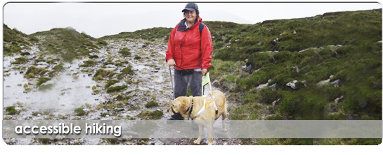
Exploring forest trails, glaciated valleys and mountain paths is accessible to everyone of every ability and is one of the best ways of keeping fit and healthy as well as experiencing a wonderful sense of well being.
Disabled Hiking

The great thing about hiking is that up to all five senses can be stimulated; from the feeling of warm sunshine or soft rain on your face, to the sound of splashing streams; from views over ice-carved countryside or black mountain lakes, to the tangy taste of wood sorrel in your mouth, or sharp smell of pine forests.
Who Is It For? Anyone, of any age, who is visually impaired, blind, deaf or has mobility problems. Ability Level Needed? Average, or even below average, level of fitness. Walking speed is not important. Anyone with mobility problems needs to be reasonably steady on their feet. What Will You Get Out Of It?
Backpack Waterproof Coat & Trouser Warm Clothes Hat & Gloves Two Spare Fleeces Water Packed Lunch Sun Cream Price: €75 per person, per hike Price Includes: Transport From Killarney & Killorglin, Qualified & Experienced Mountain Guides, Tea & Coffee At Finish Dates: Sat 19th July Sat 9th Aug Sat 30th Aug Sat 20th Sept Other Details: Ideally each hiker needs to bring a sighted or able-bodied friend or family member with them to assist. This second person will not be charged for. Routes: 1. Distance : 11km Ascent : 200m height gain Beginning at 19th century Muckross House hike around Muckross Lake, through some of Ireland's oldest oak and yew woods. Past the ruins of Muckross Abbey to finish with a coffee at Molly Darcy's Pub. 2. Distance : 10km Ascent : 500m height gain Hike the Old Kenmare Road which was an old coach road and is now part of the Kerry Way. Pass a ruined famine village and climb to the top of Torc Mountain, named after the wild boars which used to thrive in the area. From here continue along a meandering path to Derrycunihy Church. 3. Distance : 12km Ascent : 450m height gain Beginning at long abandoned Gleensk Viaduct hike along a good trail through a thick pine forest. Emerge into the sunlight at the base of Beenmore Mountain. From here the narrow path follows an old Butter Road. Finish at the warm sand dunes and crashing surf of Rossbeigh Beach. 4. Distance : 13km Ascent : 470m height gain Beginning deep in the thickly wooded Glencar valley follow the Kerry Way along grassy paths. Follow alongside the deep clear Caragh River for a short time, then a narrow secretive Mass Path leads through Lickeen Woods. After this a rocky path leads through the Windy Gap into Glenbeigh. |
|||||||||||||||
|
© copyright 2009 nathan kingerlee all rights reserved | designed & managed by Kingdom Media |
|||||||||||||||